The bespectacled crocodile
by John Hall
An illustrated manual for facilitating Holistic Management in pastoral communities.
TABLE of CONTENTS: Planning of grazing
30. Relative value of paddocks
32. Finalization of the grazing plan
| The bespectacled crocodileby John HallAn illustrated manual for facilitating Holistic Management in pastoral communities. |
Some rights reserved. You may copy and distribute this manual or parts of it if you (1) credit the original authors, (2) include this notice, including the copyright license information below, and (3) on partial copies, include the following link where people may download the complete manual. English and French versions are available at
http://managingwholes.com/crocodile/
You may create and distribute derivative works, adaptations, and translations under the same conditions. If possible, please make an electronic copy available for public distribution (you can do this through ManagingWholes.com), and send the URL to the author:
If you wish to use this manual for commercial purposes, please contact the author.
Creative Commons license:
http://creativecommons.org/licenses/by-nc-sa/1.0/
![]()
INSTRUCTIONAL UNIT SEVENPLANNING OF GRAZING
|
|
|
Introduction of the planning of grazing instructional unit: (5 minutes)
Introduce this unit with a certain amount of humor, even though the subject is very serious. Indeed, the four modules of the instructional unit on planning represent the culmination of the participants efforts during the entire outreach cycle. By the end of this instructional unit, the communitys grazing management plan will be drawn up, and this is, after all, the ultimate goal of this outreach effort.
Ask participants what particular things they have noticed technicians and civil servants are doing when they visit their village before making an important decision?
· How do these visitors look? What do they always have in their hands (Answer: notebooks and ballpoint pens.)
· Why ? Is there a logical reason for walking around a village with these things in ones hands ?
Pursue this exchange, observing that collecting a lot of information in order to make an important decision means asking a great many questions that elicit a great many answers. For the exercise to be productive, one must either have a good memory, or else carry a notebook and a pen. This is why technicians and civil servants are not the only ones who use notebooks and pens in daily life.
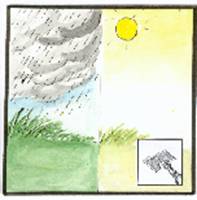
Next, explain to participants that this image of a notebook and ballpoint pen in a hand will be the icon for the four following modules, since in these modules they are going to identify the events and make the calculations needed to develop a grazing management plan. Then display the Planning of grazing icon.
MODULE # 29PLANNING OF GRAZINGRANGE-LAND MAPPING
|
|
|
PEDAGOGIC ANALYSIS
Desired situation
¨ The number of paddocks to be established in the herding communitys grazing area is determined on the basis of the mRTs and MGTs of forage plants that it wants to promote.
¨ The delimitation of these paddocks is established by taking advantage of the existing topography, vegetation, infrastructures and boundaries (whether natural or artificial).
Current situation
¨ Grazing areas are not divided into paddocks.
¨ In any case, the lack of organization on the part of users would make such a parcellary arrangement impossible and/or pointless.
Disparity between current and desired situation
There is a gulf separating anarchic and destructive use of grazing resources from rational utilization that could allow those resources to be rehabilitated.
Objectives of the module
By the end of the training session, the participants shall be able to divide their grazing lands into paddocks, define the boundaries of these paddocks, and identify them by name.
LOGISTICS
Target group :
The choice of the target group is left up to the community and the outreach team. In any case, the target group must include representatives of at least the following:
¨ the pastoral management committee
¨ auxiliary herdsmen
¨ shepherds or cattle drivers
|
|
|
|
|
|
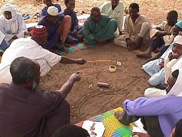
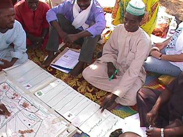
Participants sketch out the map of their village lands on the ground. Details are indicated with twigs and labels provided by the facilitator. (37/09) |
|
Exercise utilized by the module :
Mapping building (Srinavasan, p. 99)
Walk-through transects
Graphic supports: :
Folder # 29
Approximate duration of the module :
2 to 2 1/2 hours
IMPLEMENTATION
1. Introduction of the module
Introduce this module by pointing out the connection to the preceding module, which showed that parceling (i.e., the subdivision of the grazing area into a variable number of smaller paddocks) was the only way to get the herd to adhere to the recovery or resting (mRT) and grazing (MGT) times of the plants that the community wants to promote. This is why the participants calculated the minimum number of paddocks needed. But how should the grazing area be divided into paddocks? To do that, one must draw a map of the grazing area.
2.Production of the site map
Ask participants to recall the village map that they drew at the beginning of the outreach cycle. The same map cannot be re-used, since it covered only the village and its immediate environs. It will now be necessary to cover the entire space utilized by the livestock. Since they already acquired some practice drawing the village map, participants will have no trouble drawing a map of their grazing area now.
ü Mini brainstorming session on identification of landmarks
Before starting to draw, have a mini brainstorming session to allow participants to identify things that might serve as landmarks for their map. Have them name, for example, encampments, natural borders, paths, wells, water points, rivers, ponds, dunes, firebreaks, windbreaks, fields, cliffs, forests, etc. , indicating where they are in the vicinity.
ü Production of the map
Suggest that participants do a rough draft on the ground, which is easier to correct than paper, and then propose that they discuss and modify this first iteration before transcribing it to the flip-chart.
Show landmarks identified in the brainstorming by using twigs, pebbles, and any small discarded objects lying around, as well as the small village infrastructure labels contained in the folder for the module. Ask questions in order to elicit information: about places, the people that occupy them, the facilities that exist and conflicts that could possibly occur in connection with their utilization. If necessary, adjust the initial schema. When the participants are satisfied with their work, ask them to transfer this map to the paper on the flip-chart.
ü Initial attempt to establish the scale of the map
This step is crucial. If (as usually happens) no reference map is available, a very approximate estimate will have to suffice. For example, if the community is unfamiliar with the metric system, the participants may indicate how much time it takes to walk from the village to one of the places on their grazing area. One might also estimate these distances using the odometer of a vehicle driven by someone accompanied by a member of the community.
3. Parceling out the site
The parceling out of the site can now proceed. If the initial map is still on the ground, the exercise can continue on the ground, since there will be many hesitations and corrections. The sketch on the ground will be transferred to the flip-chart once the participants are satisfied with their work.
Ask them first what information they need in order to draw the paddocks. (Answer: they need to know the number of paddocks that was calculated during the previous module on the basis of the MGT and mRT.)
ü Identification of constraints
Before they try to envisage the borders of the paddocks, ask participants to keep in mind at all times the constraints to be considered drinking, crop protection, animals propensity to cluster around dwellings, etc. -- in connection with the daily internal circulation of livestock between the paddocks.
ü
Demarcation
Ask participants to study their map carefully, keeping all these important factors in mind, and to draw the borders of the paddocks based on the previously identified constraints.
In addition, emphasize that, whenever possible, it will be advantageous to have the borders of parcels coincide with existing borders: e.g., ravines, dunes, cultivated fields, changes in vegetation, roads, paths, villages, firebreaks, etc.
¨ When they are on the verge of completing the demarcation of their paddocks, ask participants if they are satisfied with the size and shape of the paddocks they have designed;
¨ When the participants are satisfied, transfer the sketch from the ground to the existing map on the flip-chart.
ü Naming of paddocks
At this point, the issue of naming the paddocks should be raised, so that, if they are very numerous, each one can be specifically referred to. Herders generally identify the various parts of their grazing area by commonly used names that they will transfer naturally to paddocks.
After conferring briefly, participants will come up with names that will be immediately written, in the language and script of the community by the secretary, onto the map on the flip-chart .
In order to facilitate the later steps, each name shall be preceded by a number (e.g., 1, 2, 3, etc.) so that people who neither speak nor read the local language can interpret the management map that will be developed subsequently. In any case, the villagers have watches and thus can read these number. They wont use these numbers, anyway, since they will be identifying parcels by name.
ü Area
Finally, one should endeavor to estimate, with participants, the approximate surface area of each paddock. This should be done based on the map and using its approximate scale. Note that more precise estimates can be made later, but at this stage, it is useful to have at least a preliminary idea of the dimensions of these paddocks.
4.Walk-through transect of paddocks
It
is essential to conduct a walk-through, during which the participants, armed
with the rough map that they have temporarily detached from the flip -chart,
accompany the outreach team to the paddocks located close to the training site.
You will guide the participants reflections, acting as a resource person in
the least directive way possible.
¨ Are participants sure that they have correctly rendered the shape and size of the paddocks?
¨ Ask participants to check themselves the accuracy of the landmarks they have shown (structures, wells, ponds, cultivated fields, etc.)
¨ Ask participants also to imagine the various routes that the livestock would need to take every day to reach this paddock and to indicate if they will have to vary with the seasons.
¨ Introduce the notion of relative value among the paddocks, by asking participants to observe the richness of the vegetation and to indicate how it compares to the rest of the grazing area;
¨
Can the paddock be used in
every season?
Of course, if the actual planning is taking place during the outreach session, , the walk-through will be conducted with the entire planning team (i.e., management committee, herders, auxiliary) over all the paddocks so as to confirm their exact boundaries, markings, relative value, etc.
5. Synthesis and adjustments to the map
Back to the training site, have participants summarize the information they were able to glean from the walk-through, and study the map once more with these observations in mind. Have them make the needed adjustments, if any are needed.
Remind the participants that it is important to keep in mind the idea that a map of this type, like the grazing plan, can be modified at any time, and that they will indeed have a chance to do that before they finish the exercise. Invite applause for a job well done.
6. Brainstorming : ways of marking boundaries
Finally, now that they have shown the boundaries of paddocks on their map, ask participants how these boundaries should be marked on the grazing area itself, for the information of shepherds and visitors.
Insist on the fact that this boundary-marking is only indicative and must not prevent access to the grazing area to other users (as would be the case, for example, with barbed wire).
Emphasize that there are many ways to do this, depending on the region and the customs, and ask them to think of some. The following ideas may be put forth:
¨ Stakes
¨ Painted marks on trees
¨ Piles of rocks (cairns)
¨ Thorny hedges
¨ other.
With the participants, study the advantages (e.g., low cost, locally available materials, sturdiness, etc.) and disadvantages of the various solutions envisaged and agree on the one that appears best suited to their specific circumstances.
7. Transition to the next module
If the participants have no further questions or comments, introduce the next training session, which will deepen their knowledge of the paddocks that they have just created, so that they can exploit them more efficiently in the future. Display the icon representing the «range-land mapping» and put it beneath the icon for the planning of grazing instructional unit.
NOTES TO THE TRAINER
q In preparing this training module, you will do a bit of research to see if is any cartographic document of any type exists that might cover the site of the community, and that could be made available to the community at the beginning of the exercise. The scale of such documents shouldnt be smaller than 1/100,000th, and might include:
ü Commercial road maps
ü Cadastral maps;
ü Aerial photos;
ü Satellite images
ü Sketches done for other projects and programs, etc.
q
At this stage, as said before,
the resource management specialist of the outreach team can indicate to the
participants that the increased number of paddocks, aside from the fact that it
allows for closer monitoring of mRTs and MGTs, allows livestock to move more
frequently in the direction of fresh ungrazed grass and, therefore, to be
better nourished.
q
Caution! The fact that they
used the circle in the parceling of the grazing area module
does not mean that participants can be imprecise in representing their own
grazing area.
MODULE # 30PLANNING OF GRAZINGRELATIVE VALUE
OF
|
|
|
PEDAGOGIC ANALYSIS
Desired situation
Livestock
moves about within the grazing area from one paddock to another in accordance
with the grazing plan established on the basis of the relative value of each
paddock.
Current situation
Livestock moves about in an unplanned fashion, under the pressure of external events (e.g., rainfall, competition from other users, parasitic diseases, etc.)
Disparity between current situation and desired situation
¨ The concept of the relative value of paddocks cannot be grasped since paddocks do not exist;
¨
Herders strategies consist in
providing their animals with the best vegetation rather than in managing
grazing resources.
Objectives of the module
By the end of the training session, participants shall be able to gauge the relative value of each paddock and to plan the movements of livestock between them, taking into account the mRTs and MGTs of desired plants
LOGISTICAL ASPECTS
Target group :
The choice of the target group is left up to the community and the outreach team. It should in any case include representatives of at least the following:
· the pastoral management committee
· auxiliary herdsmen
· shepherds or cattle drivers
|
|
|
|
|
|
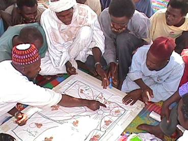
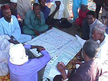
All practitioners of rapid rural appraisal are familiar with the technique of using small pebbles to show the relative value of parcels (38/14) |
|
Exercise utilized by the module :
Matrix ranking and scoring
Graphic supports:
Folder # 30, limited to the relative value icon
Approximate duration of the module
90 minutes
IMPLEMENTATION
1. Introduction
Establish the connection between the preceding module and this one by asking participants to study carefully the map they have made, and to imagine the various paddocks in all their diversity. Do they perceive significant differences between paddocks? Why is it important to take these possible differences into account?
Follow up on this introduction by indicating that in this module, they will expand on the idea of taking the quality of the various paddocks into consideration in planning the utilization of the grazing area, and of adhering to the resting and grazing times of the plants discussed in the previous modules.
2. Preliminary observations
¨ During the actual planning of the grazing area, the procedure described below must be applied in turn to the rainy season and the dry season. In order to avoid unnecessary repetition, the procedure will be described only once in this module.
¨ For this module, the facilitator must gather about a hundred small pebbles. (These are not provided in the modules graphic support folder. )
¨ The map of the grazing area attached to the flip-chart is placed flat on the mat, and participants gather around it in such a way as to allow them to estimate the relative values of the different paddocks (See illustration above). To indicate this, participants will place small pebbles on each paddock represented on the map.
3. Relative value of each paddock
The point of the exercise is to recognize that all parts of the same grazing area do not have the same vegetation, and thus do not have the same nutritive value for livestock, and that this must be considered in establishing the grazing management plan.
ü Mini brainstorming session on factors determining relative value
Once they have made the above observation, ask participants to identify quickly the factors that determine fodder quality or the relative value of each paddock. Why do they assert that one paddock is richer or poorer than another? According to what criteria?
¨ Mix of different species
¨ Density of the vegetation
¨ Vegetative phase of the plants, etc.
When the ideas seem to have been exhausted, ask one participant to summarize the criteria that have just been identified, and that will be used in estimating the relative value of the paddock.
ü
"Tagging" the
parcel with the highest value
Next, have participants identify the richest paddock, i.e., the one with the best quality vegetation according to the criteria they have just identified (the area of the paddock is not taken into account). The participants place six small pebbles on this paddock to represent the highest relative value. The other parcels can only receive an equal or smaller number of pebbles.
ü Evaluation of the poorest paddock
The participants review the other paddocks one after another and identify those they feel have the poorest vegetation. They place a number of pebbles on this paddock in relation to the six that they placed on the richest paddock: e.g., 3 pebbles if it seems half as rich, 2 if it seems only a third as rich as the best paddock, etc.
Be careful: We are dealing here with the relative value per unit of surface area, e.g., per m2, and not with the total volume of fodder (taking surface area into account).
ü
Evaluation of paddocks of
intermediate value
Since the relative values of these paddocks necessarily lie between those of the richest and poorest, the relative values of the intermediate paddocks are easily estimated by placing on them an intermediate number of pebbles.
ü Another "round"
Before concluding the exercise, have participants go through the paddocks once again mentally to be sure that their relative value estimates are plausible and to correct them if necessary.
4. Duration of stay in each paddock
ü First "round" of estimates of duration of grazing
Remind participants of the concept of the MGT. Have them establish the duration of stay in each paddock considering (apart from the maximum grazing time, MGT) the animals nutritional needs, which will be met to a greater or lesser degree, for a given period of time, depending on the relative value of each paddock and on that paddock's size. Indeed, it is obvious that for a given MGT, animals must not stay as long in a small, poor paddock as they can in a larger paddock of greater relative value. Ask participants:
¨ How many days at most -- can the livestock stay on each paddock? Could they stay for the entire duration of the MGT on paddocks that have the lowest relative value?
¨ If that is the case, can the animals duration of stay on such a paddock be shorter than the MGT?
¨ As an example, if the herd can remain on the parcel with the highest relative value (represented by 6 pebbles) over an MGT of 3 days, one can deduce that they should only stay a single day on a parcel having an equivalent surface area but a relative value only one third (2 pebbles) as high as that of the reference parcel;
¨ Even though the determination of the number of days of stay is linked to relative value, there is no mathematical correlation between them.
Once the participants have agreed on a duration of stay on a paddock, they record this on the grazing map by marking the corresponding paddock with the appropriate number of small sticks.
ü Checking for adherence to the mRT
Since the stay on each paddock is necessarily equal to or less than the MGT, which was in turn applied to the richest paddock, and since the initial number of paddocks was calculated very tightly, one can predict that, by adding up the actual duration of stay of all the paddocks, one will arrive at a recovery or resting time (mRT) shorter than that which had initially been deemed desirable.
ü Adjustment of the number of paddocks
Once they notice this, participants often suggest to increase the duration of stay in the richest paddock beyond the MGT. It should then be pointed out that stretching the presence of animals beyond the MGT shouldnt be done and that they should imagine another solution.
¨ Should the livestock be fed with supplementary purchased fodder?
¨ Should they leave the site and go graze on the neighbors land?
¨ Should they subdivide one or more paddocks?
This last is obviously the most practical solution, and participants will not take long to figure it out. Once they do, they should be asked the following question :
¨
Which paddocks lend themselves
most easily to such a subdivision? (Answer: Those with the highest relative
value? The largest ones?)
Indicate approval when participants decide to subdivide one or several paddocks until the calculation of the resting time between two successive stays is equal to, or greater than, the mRT. Repeat this same procedure with paddocks that have a lesser relative value, until everyone accepts the number of paddocks and the grazing duration in each one. Record the amended grazing duration using small sticks. Conclude the exercise by reminding participants that:
¨ in subdividing paddocks, one must always keep in mind the constraints (e.g., circulation of livestock) that were taken into account during the initial parceling of the grazing area;
¨ new paddocks need more names ( and additional numbers).
8. Transition
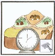
If the participants have no further questions or comments, show the icon that represents relative value of paddocks and place it next to the other icons for the instructional unit on planning of grazing. Then, introduce the next module which deals with the identification of foreseeable events and constraints.
NOTES TO THE FACILITATOR
It must be
perfectly clear to participants that the demarcated paddocks have different
relative values and varying sizes. Therefore, the period of utilization by
livestock cannot be the same for all of them.
MODULE # 31PLANNING OF GRAZINGEVENTS AND
|
|
|
PEDAGOGIC ANALYSIS
Desired situation
Events and constraints that might come up during the resource management process are identified in advance as elements intrinsic to this management.
Current situation
Problems encountered are dealt with on a case-by-case basis, as they come up, and are managed in a crisis mode rather than in the context of an overall forecasting strategy.
Disparity between current and desired situation
¨ Herders are disorganized and act in an improvised fashion
¨ They are acted upon by events and constraints and react to them, instead of foreseeing and controlling them.
Objectives of the module
By the end of the training session, participants will be able to:
¨ identify, and situate in time, events and constraints that must be considered in developing a grazing management plan;
¨ define strategies that provide solutions in advance to these events and constraints.
LOGISTICS
Target group
The choice of the target group is left up to the community and the outreach team. It should in any case include representatives of at least the following:
· the pastoral management committee
· auxiliary herdsmen
· shepherds or cattle drivers
|
|
|
|
|
|
The sessions "secretary" spreads out before him the monthly calendar of events, which are represented by drawings or small labels. (38/17) |
|
Exercises used by the module :
Brainstorming
Development of a "calendar of events
Graphic supports :
Folder # 31
Approximate duration of the module
1 hour
IMPLEMENTATION
1. Introduction / transition
Establish the connection with the preceding module by asking participants to summarize what they have accomplished thus far with the map of their grazing land.
Show them that, if they add some indications concerning foreseeable events and the grazing calendar (livestock movements) to the information already on their village map, it goes beyond being a map and becomes instead a management plan indicating « what to do, where and when ».
2. Brainstorming : foreseeable events and constraints
Ask participants to list events that they can predict and that they know have a direct and unavoidable impact on pastoral management. There is no point in noting unforeseeable events (e.g., serious epidemics) and those that have no direct bearing on the way grazing land is managed (e.g., livestock thefts). Participants will cite, for example :
¨ the beginning of the rainy season (e.g., date of the first rains)
¨ probable date of arrival of transhumant herders;
¨ emergence of poisonous plants;
¨ flooding in some parts of the grazing area;
¨ birth/suckling of young;
¨ drying up of ponds and wells;
¨ crops; cropping techniques, harvest;
¨ periodic livestock vaccination;
¨ emergence of flies, parasites;
¨ predators
¨ particularly hot or cold seasons;
¨
Others, etc.
Each time an idea is put forth, bring out the corresponding (5x5 cm) label and be sure that all participants understand it the same way. Announce that these labels will be used to develop a calendar of events during the next step. Ask participants to quickly draw new labels if events are identified for which there is no illustration.
3. Situating events in time
¨ In front of the participants, unfurl a long roll of flip-chart paper about 30 cm wide that has been reserved for this purpose (and which will be reffered to as the calendar of events, and ask them to mark on it the sequence of months over the course of an entire year;
¨ Each month may be represented by about 30 cm of rolled-out paper, depending on the density of events that the participants want to record;
¨ The names (or numbers) of the months are written in by the village « secretary », starting with what they consider to be the « beginning » of their cropping year (which is usually the beginning of the rainy season).
¨ Be sure that everyone has a clear understanding of the meaning of the "calendar of events.
¨ Since the important events and constraints have already been identified, it is now possible to affix the labels representing them to the corresponding places on the " calendar of events;
¨ Have participants discuss each of these events and constraints, and estimate their frequency, severity and duration;
¨ Emphasize the importance of events represented by the dates of entry and departure of their own animals from the grazing area, if they are transhumant, and of other users, if there are any.
¨ Have the village "secretary" record details deemed important for each of these events onto the calendar of events in the local language.
Once the participants feel that their calendar of events is complete, one can envisage transferring its contents onto the map of the grazing area.
However, since the map is at this stage already covered with quite a bit of information, it may be preferable to keep the calendar of events separate and to refer to the two documents side by side.
4. Analysis of paddocks and preparation of strategies
Congratulate participants on a job well done and invite them to pay close attention to their map and to the information it contains. Indicate that, before going on to the last planning step, they need to do one last thing:
¨ Among the events and constraints that have just been recorded on the calendar of events, they need to identify those that would have a direct impact on the accessibility or availability of one or more paddocks over a given period;
¨ For events that would not have any impact on the accessibility of the paddocks, participants should be asked to imagine strategies for either avoiding or minimizing their negative consequences, or for taking advantage of them. Focus on each event in turn, and ask the communitys « secretary » to record the suggestions accepted on the calendar of events. At the end of the exercise, the « secretary » re-reads the groups suggestions that have been entered into the calendar of events and makes changes to them if the participants wish.
5. Lessons to be learned / transition
q Finally, have participants reflect on the activity they have just completed. What are the most importance lessons they have derived from it ?
q Point out that the map is still not finished. What is still missing ? (Answer: The circuit of the livestock within the paddocks). This will be the subject of the next module.
q If the participants have no further questions or comments, display the icon representing « events and constraints » and place it next to the other icons. Then introduce the next session, which will consist of completing the grazing management plan
MODULE # 32PLANNING OF GRAZINGFINALIZATION
OF
|
|
|
PEDAGOGIC ANALYSIS
Desired situation
Rational resource management is based on upon the overall/holistic planning of resource use, established in a collaborative fashion by all users.
Current situation
¨ Absence of planning of grazing;
¨ Individual, improvised and anarchic grazing scenarios
Disparity between current and desired situation
¨ Herders feel that they can no longer control the utilization of their resources;
¨ Traditional resource utilization systems have become disorganized and can no longer respond to the considerable constraints weighing on these production systems.
Objectives of the module
By the end of the training session, participants will be able to finalize a grazing management plan that can be accepted and applied by all users.
LOGISTICS
Target group :
The choice of the target group is left up to the community and the outreach team. In any case, it must include representatives of at least the following:
· the pastoral management committee
· auxiliary herdsmen
· shepherds or cattle drivers
|
|
|
|
|
|
Participants are always very pleased with themselves once they have completed the calendar of events and the snake calendar of the grazing management plan (39/04) |
|
Exercises utilized by the module:
Cartography (circuits of livestock movements)
Production of the "snake calendar"
Graphic supports
Folder # 32 limited to the single icon : « finalization of the grazing plan »
Approximate duration of the module:
90 minutes
IMPLEMENTATION
1. Introduction / transition
Have participants look closely at the map of their village lands that they prepared themselves, and discover what is still missing before it can be a true grazing management plan. The missing element is an indication of livestock movements and the dates of these movements.
Remind them also that they are only working on the plan for the rainy season. A new plan for the dry season will need to be worked out at the end of the rainy season.
2. What is the status of the plan ?
Take out the icons for the three modules previously done, during the training session. Ask participants to state what they remember about each of these modules:
¨ "range-land mapping" module : participants have identified the paddocks, the itineraries of the animals, and the main characteristics of each paddock.
¨ "Relative value of paddocks" module: participants adjusted the length of the animals stay on each paddock;
¨ "Events and constraints" module: Participants identified the seasonal events and constraints that must be taken into account in the final grazing plan.
3. Livestock movements within the paddocks
ü Circuits of livestock movement
Remind participants first that the animals itineraries were mentioned in connection with the « range-land mapping » module. For this exercise, they will need a copy of the grazing area map drawn up during the preceding planning modules.
If the participants live in encampments scattered over the grazing area, you will have to ask them to organize themselves into as many small groups as there are encampments. If, on the other hand, the encampments are grouped together, participants will remain in a single group. For each encampment introduced, the exercise will consist of ensuring that animals daily movements between the encampment, the grazing area and the water point can occur under good conditions and cover distances acceptable for the animals and their keepers.
The exercise must be done for both the rainy season (when there are often ponds in the paddocks) and the dry season (when ponds are dry and animals must cover greater distances to get water.)
ü Identification of available paddocks
The information needed to execute this step in the finalization of the plan is entirely contained within the "calendar of events" prepared during the « events and constraints » module; have the participants refer back to that.
ü Order of utilization of paddocks
Once participants have identified the paddocks that will be unavailable at one time of year or another, they should choose the order in which the paddocks will be grazed by the herd. This order must also take into account the foreseeable constraints recorded in the aforementioned "calendar of events". For example, a decision should be made to pass through the best quality parcels at the time when calves and lambs are being born. On the other hand, grazing in bottomlands will be postponed until the end of the rainy season when there is less risk from parasitic insects, and son on .
ü Duration of stay within the paddocks
Once the participants are satisfied with the circuits envisaged, ask them to indicate the intervals of stay on each paddock, which have been established at the end of Module # 30 "Relative value of paddocks". For example, three days in paddock 1, with an arrow pointing towards paddock 4; two days in paddock 4, with an arrow pointing towards paddock 3; three days in paddock 3, and so on, until all available paddocks have been covered for this rainy season. Point out that the numbering of the paddocks, done at the time they were given names (range-land mapping module) bears absolutely no relationship to the order in which they are grazed by the livestock, which may be entirely different.
4. Preparation of the roll-out or "snake calendar
ü Preparation of the visual aid known as the snake calendar;
At this stage, all the information needed to compile the management plan has been recorded on the map and on the calendar of events. This data must now be represented on the snake calendar, which rolls out around the map of village lands.
(If participants seem a bit lost, the facilitator can have them take a quick look at an example of a management plan obtained elsewhere.).
Since the seasons do not correspond to the half-yearly approach adopted, the grazing management plan for the rainy season will be preceded by the end of the cool season and will be followed by the beginning of the dry season.
The snake calendar consists of a continuous unbroken line going all the way around the map of the grazing area. Since every management plan is supposed to cover roughly one half of the year, ask participants to subdivide this line into 6 equal parts (for the months), 27 small sections (for the weeks), and 185 units (for the days). The participants will proceed in various ways: allow them to work it out themselves.
ü "Marking" of the agro-pastoral year
Since the snake calendar covers only a part of the year, ask participants to decide when they want it to start. In other words, what is the beginning of their agricultural year ? Some communities will choose the beginning of work in the fields in the spring, or the beginning of the rainy season in summer. It is up to them to choose where to mark off their snake calendar a the point where they want the snake to begin.
ü Calendar of movements :grazing management plan
Finalization of the grazing management plan consists simply of making small marks on the « snake » in different colors for each change of paddock, based on the numbers and arrows inscribed a little earlier on the paddocks. By writing the number of the paddock opposite the corresponding segment of the snake calendar. During implementation, herders (who call the paddocks by their names) as well as outsiders (who refer to them by numbers) will be able to verify at any time where the animals are on the grazing area, by refering only to the grazing management plan.
When the snake is entirely covered with data (dates of livestock movements, paddock numbers, etc.), the communitys grazing management plan is complete. Congratulate participants and applaud enthusiastically.
5. Lessons to be learned: wrap-up skit using the icons
ü Putting the holistic model in perspective
Acknowledge that the four last modules were a bit complicated, to the point where it was sometimes difficult to completely understand what was going on. This is why a bit of review may be helpful. Take out the following icons and ask participants to explain the meaning of each one:
¨ Remind those present that at the beginning of the training session, participants agreed on a landscape goal that they would like to see materialize around their village;
¨ After that, the ecosystems building blocks were studied, in order to identify the village lands "weak link";
¨ Then, an effort was made to better chose the tools capable of rectifying the existing situation, using animal impact and time, in particular.
¨ Finally, a grazing management plan was established.
ü Preparation of the wrap-up skit on the holistic model
Ask participants to consent once more to act out a small theater piece, but indicate that the facilitator will neither designate the characters nor suggest the plot.
This time, it is up to the participants themselves to create this short performance on the basis of the four icons they have just been shown: the landscape goal; the ecosystems building blocks, the weak link and the management tools. The participants are invited to portray as many characters as they want and to come up with any story, provided that these four ideas are included.
You should ensure that participants have a good understanding of their task. You give them the icons so that they can remember what they are supposed to do, and give them 15 minutes to prepare the skit. After a few minutes, you check to see how far along they are.
When they are ready, organize the presentation, have the audience and actors take their places, and begin the skit, which will last about five minutes. Once the presentation is over, applaud, and ask the audience to interpret the skits main message. Is it clear to everyone that the grazing management plan that has just been finalized is supposed to enable them to use tools that will strengthen the weakest link in their ecosystem and that in this way they have a chance to modify the landscape in a way that will allow them to achieve their goals in terms of production and quality of life?
6. Transition to implementation of the management plan
If the participants have no further questions or comments, explain to them that with this module, they have completed the instructional unit on planning of grazing (take out the icon representing « finalization of the grazing plan»). Place the generic icon for the « planning of grazing » unit on the mat, and place the icons for the four modules next to it.
Announce to participants that the next instructional unit will deal with herd management, and that subsequent modules will cover aspects of the implementation of the grazing management plan developed during the present module.